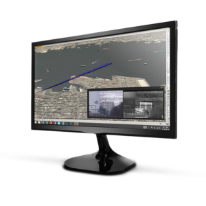

Powerful simulation and layout software
-
SATELITE IMAGING INTEGRATION
Raven utilizes Google Maps satellite imagery worldwide to provide the most accurate site representation possible.
-
OVERLAY IMAGERY FUNCTION
Import your future site plan into Raven and overlay it onto Google Maps before laying out your cameras.
-
CREATE YOUR PDF REPORT
Create your plan, then output the PDF report complete with detailed GPS camera locations and models ready for quote building.